[the_ad_placement id=”adsense-in-feed”]
– globalbihari bureau
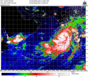
New Delhi: The Cyclonic Storm ‘NISARGA’ is very likely to intensify during next 12 hours and is very likely to cross north Maharashtra and adjoining south Gujarat coast between Harihareshwar and Daman, close to Alibagh (Raigad District, Maharashtra) tomorrow afternoon as a Severe Cyclonic Storm with a maximum sustained wind speed of 100-110 kmph gusting to 120 kmph.
Storm surge of about 1-2 meters height above astronomical tide is very likely to inundate low lying areas of Mumbai, Thane and Raigad districts and 0.5-1 meter height above the astronomical tide is likely to inundate low lying areas of Ratnagiri district during the time of landfall, the Cyclone Warning Division of the India Meteorological Department, warned on Tuesday.
Fishermen are advised not to venture into Eastcentral and Northeast Arabian Sea and along &off Karnataka-Goa-Maharashtra-south Gujarat coasts till Wednesday.
[the_ad_placement id=”content-placement-after-3rd-paragraph”]
North Konkan (Mumbai, Palghar, Thane, Raigad districts), north-central Maharashtra, coastal Karnataka, central Maharashtra and Marathwada are very likely to experience extremely heavy falls ( ≥ 20 cm in 24 hours) tomorrow.
Gale wind, speed reaching 70-80 kmph gusting to 90 kmph, is already prevailing over east-central Arabian Sea. It will gradually increase with speed reaching 80-90 kmph gusting to 100 kmph, over eastcentral Arabian Sea off south Maharashtra and Goa coasts by tonight and further becoming 100-110 kmph gusting to 120 kmph over east-central Arabian Sea along and off Maharashtra (Raigad, Mumbai, Palghar, Thane) coast from tomorrow morning. Gale wind, speed reaching 80-90 kmph gusting to 100 kmph, is likely along and off Valsad, Navsari districts of Gujarat, Daman, Dadra & Nagar Haveli and along and off northeast Arabian Sea, Ratnagiri, Sindhudurg districts of Maharashtra and 70-80 kmph gusting to 90 kmph along & off Surat and Bharuch districts of south Gujarat from tomorrow noon.
The cyclone is likely to cause major damage to thatched houses, huts, roads, coastal crops, salt pans and uproot trees. Roof-tops may blow off and Unattached metal sheets may fly. It is also likely to cause damage to power and communication lines.
On Tuesday, Prime Minister Narendra Modi reviewed the emerging situation in the wake of cyclone conditions and urged people to take all possible precautions and safety measures.
Also read: Centre braces up for cyclone in Arabian sea
With the cyclonic storm Nisarga brewing in the Arabian Sea, all teams have been put on alert and are in readiness to respond to any requirement of Humanitarian Assistance and Disaster Relief (HADR) during the storm period.
National Disaster Response Force (NDRF) has deployed 40 teams in the States and Union Territories and additional teams are also being airlifted. Rescue and relief teams of the Army and Navy along with ships and aircrafts of the Navy and Air Force have been put on standby. Ships of the Coast Guard are already engaged in rescuing fishermen at sea.
In Mumbai, the Maharashtra Naval Area has been kept on standby with five Flood Rescue Teams and three Diving Teams throughout the monsoon season. These teams are stationed at various naval areas across the city to enable early response over a larger area. “These teams are fully equipped and have been trained for rescue operations. Recce of known flood-prone areas has been undertaken and all necessary preparations are in place,” a defence ministry release stated.
Similar arrangements have been set up within the Karwar Naval Area, the Goa Naval Area as well as Gujarat Daman and Diu Naval Areas. The respective Area and Station Commanders are in touch with the State authorities, NDRF, and State Disaster Response Force to be able to respond to a crisis situation in the shortest possible time. Ships of the Western Fleet have been also embarked with Humanitarian Assistance and Disaster Relief (HADR) bricks to provide succour to coastal areas inundated due to heavy rain.
Forecast track and intensity are given in the following table:
| Date/Time(IST) | Position
(Lat. 0N/ long. 0E) |
Maximum sustained surface wind speed (Kmph) | Category of cyclonic disturbance |
| 02.06.20/1730 | 16.3/71.3 | 70-80 gusting to 90 | Cyclonic Storm |
| 02.06.20/2330 | 17.0/71.5 | 80-90 gusting to 100 | Cyclonic Storm |
| 03.06.20/0530 | 17.7/72.0 | 90-100 gusting to 110 | Severe Cyclonic Storm |
| 03.06.20/1130 | 18.5/72.7 | 100-110 gusting to 120 | Severe Cyclonic Storm |
| 03.06.20/1730 | 19.2/73.3 | 90-100 gusting to 110 | Severe Cyclonic Storm |
| 04.06.20/0530 | 20.6/74.5 | 50-60 gusting to 70 | Deep Depression |
| 04.06.20/1730 | 22.0/75.7 | 30-40 gusting to 50 | Depression |
[the_ad_placement id=”sidebar-feed”]


