Bay of Bengal
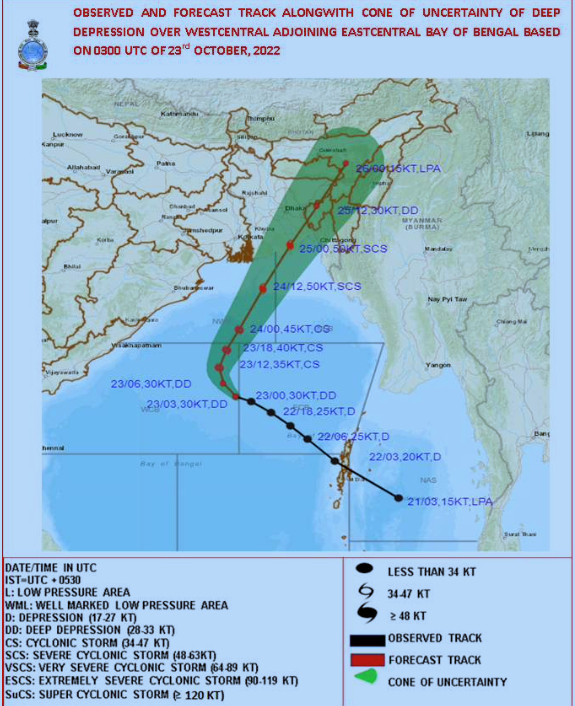
Kolkata: A depression is very likely to intensify into a severe cyclone ‘Sitrang‘ over the central Bay of Bengal tomorrow (October 24, 2022), and is likely to cross the Bangladesh coast between Tinkona island and Sandwip, close to Barisal around October 25, 2022, an updated bulletin number 8 released at 1730 hours by India Meteorological Department, stated today.
An astronomical tide of about 5-6 metres in height is likely along and off the West Bengal-Bangladesh coast on October 25, the India Meteorological Department had earlier warned in its 2 pm bulletin today and advised fishermen not to venture into the central Bay of Bengal. It further advised that people should remain in safe places in West Bengal.
The earlier report had stated that the sea condition would be ‘high to very high’ over the north Bay of Bengal along and off Bangladesh-West Bengal coasts on October 25. It would be ‘high’ over west-central and adjoining east-central and north Bay of Bengal on October 24 itself, and will become ‘rough to very rough’ along and off Odisha-West Bengal-Bangladesh coasts and would become ‘very rough to high’ from tomorrow evening along and off West Bengal-Bangladesh coasts.
On October 25, gale wind speed reaching 90-100 kmph gusting to 110 kmph is likely over the north Bay of Bengal and along and off Bangladesh coast; 70-90 kmph gusting to 100 kmph likely along and off 24 Parganas District and 60-70 kmph gusting to 80 kmph along and off east Medinipur district off West Bengal coast till morning. It would gradually decrease, the IMD said. It warned that tidal wave of about 2.0 m height above astronomical tide is likely to inundate low-lying areas of Bangladesh coast near the landfall area around the time of landfall.
The tidal wave of about 1.0 m height above astronomical tide is likely to inundate low-lying areas of West Bengal (North & South 24 Parganas) around the time of landfall.

The depression formed over the southeast and adjoining east-central Bay of Bengal close to the west of Andaman Islands at 8.30 am on October 22, 2022, intensified into a deep depression today morning and is very likely to move northwestwards during the next 12 hours and intensify into a cyclonic storm over the central Bay of Bengal.
It moved northwestwards and intensified into a deep depression at 5.30 am today and lay centred over west-central and adjoining east-central Bay of Bengal near latitude 15.60N and longitude 88.40E, about 640 km northwest of Port Blair, 670 km south of Sagar Island and 820 km south-southwest of Barisal (Bangladesh), at 8.30 am today,
Thereafter, it would recurve and move north-northeastwards and cross the Bangladesh coast between Tinkona Island and Sandwip, close to Barisal around the early morning of October 25, 2022.
Forecast track and intensity:

Gale wind speed reaching 80-90 kmph gusting to 100 kmph is likely over west-central and adjoining areas of east-central and north Bay of Bengal tomorrow. It would gradually increase becoming 90-100 kmph gusting to 110 kmph over the same region from the 24th evening till the 25th morning. Squally wind speed reaching 40-50 kmph gusting to 60 kmph is very likely along and off Odisha and West Bengal coasts. It would gradually increase becoming 60-80 kmph gusting to 90 kmph along and off the West Bengal coast and 50-60 kmph gusting to 70 kmph along and off the north Odisha coast from the evening.
Light to moderate rainfall at most places with isolated heavy to very heavy rainfall is likely over coastal districts of West Bengal (South and North Parganas, East and adjoining West Medinipur) on October 24. Light to moderate rainfall at many with isolated heavy to very heavy rainfall is likely over coastal districts South and North Parganas and Nadia on October 25.
Isolated heavy rainfall is also likely over the coastal districts of Odisha on October 24 and over the north coastal Odisha districts on October 25.
Light to moderate rainfall at most places with heavy to very heavy rainfall at isolated places is likely over north Assam and Arunachal Pradesh; heavy to extremely heavy rainfall is likely over South Assam, East Meghalaya, Nagaland, Mizoram, Manipur and Tripura on October 24.
Light to moderate rainfall at most places with isolated heavy to very heavy rainfall is likely over the same region on October 25 and isolated heavy rainfall is likely over Arunachal Pradesh, northeast Assam and Nagaland on October 26.
– global bihari bureau


