68 million hectares in South America, 49 million hectares in Africa, deforested
Seoul/Rome: The rate at which the forests are disappearing slowed by nearly 30 per cent from the first decade of the century to the period from 2010 to 2018, a key report launched today by the Food and Agriculture Organization of the United Nations (FAO) showed. But the earth’s tropical rainforests are still under the greatest threat, whether from livestock grazing in South America or the expansion of croplands such as oil palm plantations in Asia.
Annual deforestation decreased by around 29 per cent — from 11 million hectares per year in the decade 2000-2010 to 7.8 million hectares per year in the period 2010-2018 – according to the Global Forest Resources Assessment Remote Sensing Survey.
Net forest area losses have more than halved during the survey period, decreasing from 6.8 million hectares per year in 2000-2010 to 3.1 million hectares per year in 2010-2018.
Looking at it by region, the highest deforestation in 2000-2018 occurred in South America (68 million hectares deforested), followed by Africa (49 million hectares).

That’s despite the fact that the rate of deforestation in fact slowed down in South America as it did in South and Southeast Asia between 2000-2010 and 2010-2018.
The loss of tropical forests accounted for more than 90 per cent of the global deforestation from 2000 to 2018, at 157 million hectares – that’s roughly the size of western Europe. Yet annual deforestation in the Tropical domain actually slowed significantly from 10.1 million hectares per year from 2000 to 2010 to 7 million hectares per year in the period from 2010 to 2018.
“This survey is important, not just for the new numbers it gives us but for what it tells us about forest area trends and what’s driving deforestation, also the crucial ability it gives us to monitor how things are evolving,” said FAO Deputy Director-General Maria Helena Semedo.
“Unsustainable agricultural development and other land use continue to put intense pressure on our forests, especially in many of the poorest countries. But there are win-win solutions which we can and must scale up to feed the world without destroying our forests.”
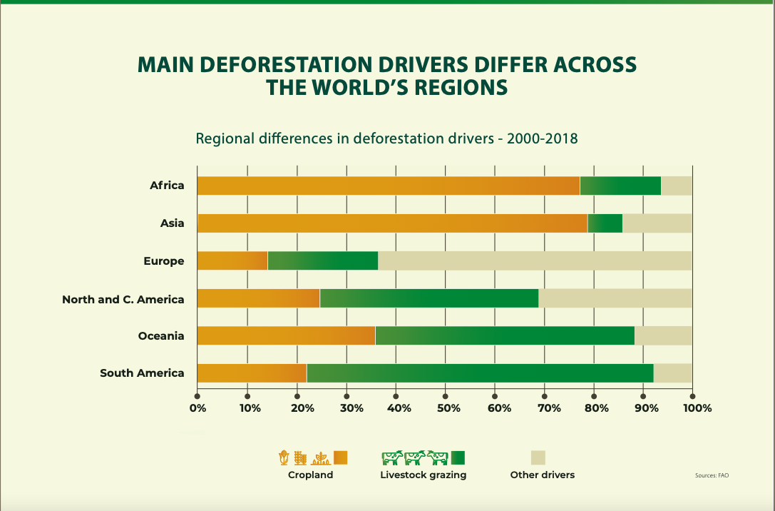
The main drivers of deforestation
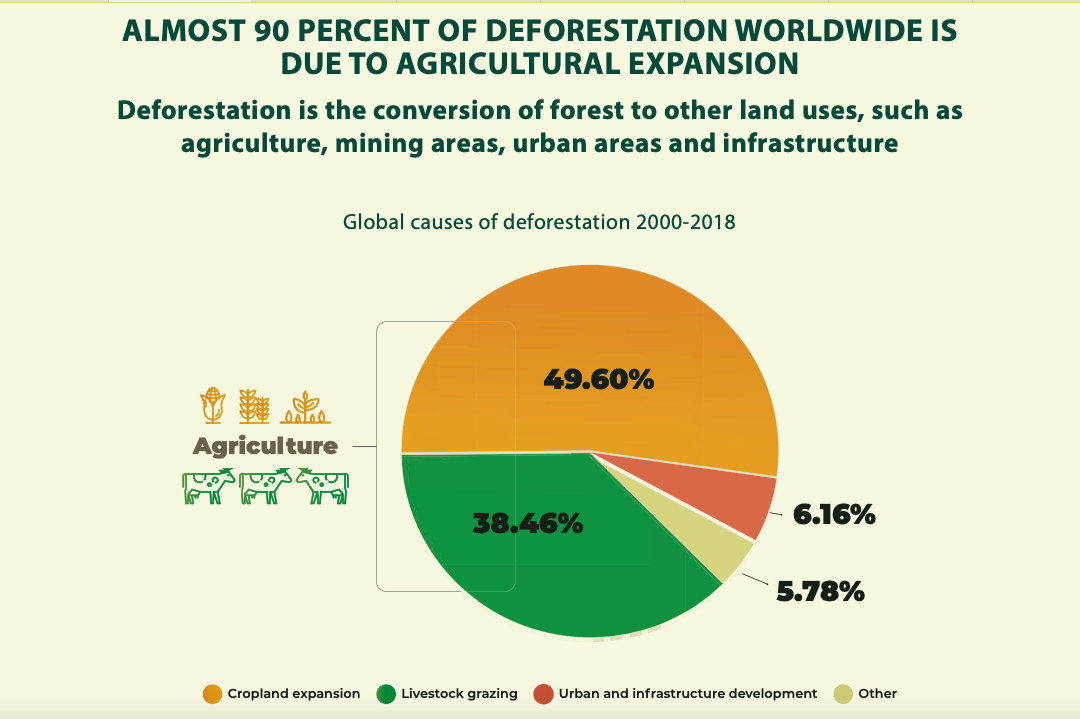
Cropland expansion (including oil palm plantations) is the main driver of deforestation, causing almost 50 per cent of global deforestation, followed by livestock grazing, accounting for 38.5 per cent. Oil palm alone accounted for 7 per cent of the global deforestation from 2000 to 2018.

The survey suggests that tropical regions of Central America are those most severely threatened by land-use conversion: 30.3 per cent of forests in the Central America tropical moist ecoregion and 25.2 per cent of Central America’s tropical rainforest were lost between 2000 and 2018. Similar phenomena were detected in Central America’s Tropical dry forest and Tropical shrubland. But the small number of samples in these ecoregions, means further investigations are needed to confirm these findings.
Global annual forest area gain showed a slight increase, from 4.2 million hectares per year in the decade from 2000 to 2010 to 4.7 million hectares per year in the period 2010-2018.
Planted forest area increased by 46 million hectares in the period 2000-2018. Almost one-quarter of forests planted in this millennium replaced naturally regenerating forests, with half of this area in South and Southeast Asia.
The FAO-led study is based on the consistent analysis of 400 000 samples by more than 800 local experts from 126 countries and territories. It has helped to build capacity at the national level by training the experts in the visual analysis of remote sensing imagery to monitor forest and land-use changes.
FAO developed the methodology in collaboration with the Joint Research Center of the European Commission. It used freely available satellite data, and the open-source Collect Earth Online tool developed together with Google, the National Aeronautics and Space Administration (NASA), the Spatial Informatics Group of the University of San Francisco, SilvaCarbon and the US Forest Service. The survey received funding from the EU and Norway’s International Climate and Forest Initiative (NICFI).
The Remote Sensing Survey, part of the Forestry Resources Assessment 2020, was presented at the XV World Forestry Congress in Seoul, which also saw the launch of FAO’s State of the World’s Forests Report 2022.
– global bihari bureau


