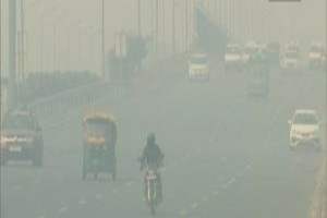
Lake Findings Help Predict Droughts, Floods, and Ecological Risk
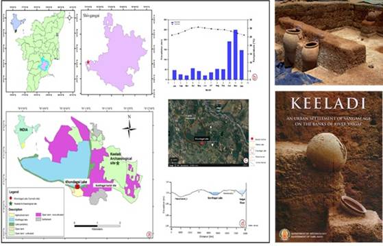
Lucknow: An inland lake on the outskirts of Sivaganga in Tamil Nadu is revealing secrets that could reshape our understanding of climate, ecology, and human history in southern India. Kondagai Lake, rich in sedimentary archives, has yielded one of the most detailed climate records from peninsular India, providing a window into 4,500 years of environmental change.
Unearthing History Beneath the Sediment
Despite Tamil Nadu’s sensitivity to the Northeast Monsoon, the region has long lacked well-dated, multiproxy lake records. Researchers from the Birbal Sahni Institute of Palaeosciences (BSIP), Lucknow—an autonomous institution under the Department of Science and Technology (DST)—including Anand Rajoriya, Pooja Tiwari, and Rajesh Agnihotri, recognised that Kondagai Lake offered a rare and invaluable record.
The lake lies near the famed Keeladi archaeological site, where excavations have revealed a sophisticated urban civilisation from the Sangam period, potentially dating back to the 6th century BCE or even earlier, pushing back Tamil history by centuries.
Researchers identified the Kondagai Lake as a rare opportunity to reconstruct past monsoon variability and its impact on ecosystems and human societies. The lake’s sediments promised to show not only climatic shifts but also how ancient societies responded to water scarcity and environmental stress.
To capture this history, the team carefully excavated a sediment profile just over one metre deep and collected 32 closely spaced samples, each representing a distinct slice of time. They applied an array of advanced analytical techniques: stable isotope analysis (δ13CTOC and δ15NBulk), total organic carbon (TOC%), total nitrogen (TN%), C/N ratios, palynofacies studies, grain-size measurements, and AMS radiocarbon dating. These allowed them to reconstruct rainfall patterns, vegetation changes, lake-level fluctuations, and flood events with a level of precision previously unavailable for inland Tamil Nadu.
Tracing 4,500 Years of Climate
The study, published in Holocene, provides the first high-resolution, multiproxy reconstruction of Late Holocene climate and lake-ecosystem dynamics in this region. It identifies three major climatic phases: the 4.2 ka arid event, a 3.2 ka dry phase, and the Roman Warm Period. Each phase shows clear linkages between monsoon variability, hydrology, and human activity.
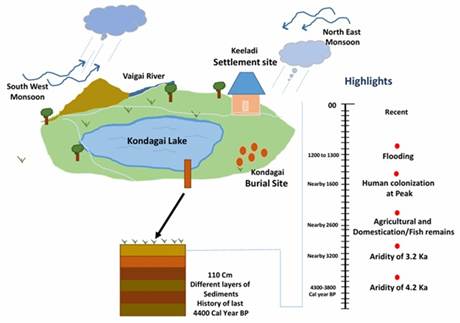
Between roughly 4,500 and 3,700 years ago, the lake’s sediments indicate a weaker Indian monsoon. Enriched δ13CTOC values and fine-grained sediments suggest that organic matter sources were dominated by aquatic plankton and C4-type vegetation (Poaceae), with low terrestrial input, while fungal production indicates shallow lake conditions. This aligns with the 4.2 ka arid event, a known global climatic stress period.
From 3,700 to 2,500 years ago, evidence points to higher water levels. Increased sand content, depleted δ13CTOC values, and higher terrestrial sediment influx suggest a more stable lake environment and stronger monsoon activity, providing a buffer for human settlements in the region. Between 2,500 and 900 years ago, the lake experienced episodic fluctuations and flooding events. Coarser sediment fractions, depleted δ13CTOC, and elevated δ15NBulk and C/N ratios reflect altered nutrient cycling during the Roman Warm Period, hinting at complex interactions between climate and human land use.
The multiproxy approach, combining geochemical, isotopic, and palynofacies data, also reveals how Indian monsoon variability interacted with El Niño Southern Oscillation (ENSO) patterns, demonstrating the integrated influence of local and global climate drivers over millennia.
From Science to Society
While the study is a landmark for climate science, its implications extend far beyond academia. By reconstructing 4,500 years of monsoon behaviour, the research provides a long-term climatic baseline that is critical for improving regional weather and monsoon forecasting. This information can help anticipate future droughts, extreme rainfall, or floods in Tamil Nadu, a state heavily dependent on monsoon-fed water systems.
The findings have immediate applications for water resource management in drought-prone districts such as Sivaganga and Madurai. Knowledge of past lake-level fluctuations, sediment inflow, and hydrological changes can guide reservoir restoration, groundwater recharge, tank rehabilitation, and climate-smart agricultural water use.
Disaster Preparedness and Risk Mapping
The research also enhances disaster preparedness as it informs flood and land degradation preparedness. Ancient flood deposits, terrestrial sediment influx, and phases of land destabilisation recorded in the lake’s sediment help identify areas vulnerable to flooding, channel shifts, and soil erosion. Authorities can use these insights to map risk zones vulnerable to flooding, channel shifts, and land degradation, particularly in the Vaigai basin and plan mitigation strategies.
Archaeology, Heritage, and Human Adaptation
Archaeologists and heritage planners stand to benefit as well. Kondagai Lake’s environmental history sheds light on how ancient societies near Keeladi adapted to water scarcity, climate variability, and ecological stress.
The findings help archaeologists interpret settlement patterns, water management strategies, and human-environment interactions, enriching regional cultural heritage planning and conservation initiatives. Understanding these adaptive strategies can inspire contemporary approaches to climate resilience.
Ecology and Biodiversity Conservation
From an ecological perspective, the study offers a scientific basis for wetland and lake restoration by documenting long-term shifts in aquatic productivity, oxygen conditions, and organic matter sources. This knowledge can support evidence-based strategies for biodiversity conservation and ecosystem management, ensuring that restoration projects reflect historical variability and resilience.
The research also demonstrates the integrated influence of Indian monsoon patterns and El Niño Southern Oscillation (ENSO) over millennia, while highlighting the combined effects of natural climate variability and human-induced land-use changes.
A Convergence of Science, History, and Policy
The research represents a rare convergence of climate science, archaeology, ecology, and water management, with lessons for the present and guidance for the future. By integrating multiproxy environmental data with insights into human history and settlement, it highlights how past climate variability, combined with anthropogenic land-use changes, shaped ecosystems and societies. For modern planners, policymakers, and conservationists, the study provides both a warning and a guide: understanding the past is crucial for navigating a climate-sensitive future.
– global bihari bureau