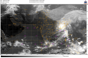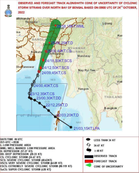
Kolkata: The India Meteorological Department (IMD) issued an ‘Orange’ cyclone warning for the West Bengal coast today. The cyclonic storm “SITRANG” (pronounced as “Si-Trang”), is very likely to continue to move north-northeastwards and intensify further into a severe cyclonic storm. It will continue to move north-northeastwards after that and is very likely to cross the Bangladesh coast between Tinkona Island and Sandwip close to Barisal around midnight today and early hours of October 25, 2022.
Tidal waves of about 2.0 metre height above astronomical tide is likely to inundate low-lying areas of Bangladesh’s coast near the landfall area around the time of landfall. Tidal waves of about 1.0 m height above astronomical tide is likely to inundate low-lying areas of West Bengal (North & South 24 Parganas) around the time of landfall.

High Sea conditions are prevailing over the west-central and adjoining east-central Bay of Bengal and the north Bay of Bengal; Rough to very rough sea conditions are prevailing along and off Odisha-West Bengal-Bangladesh coasts. It becomes high to very high from today evening along and off the West Bengal-Bangladesh coasts.
The cyclonic storm over northwest and adjoining central Bay of Bengal moved north-northeastwards with a speed of 28 kmph during the past 06 hours and lay centred at 1730 hours IST today near latitude 20.7 degree N and longitude 90.10 degree E, about 230 km southeast of Sagar Island and 320 km south-southwest of Barisal(Bangladesh).

In West Bengal, light to moderate rainfall at most places with isolated heavy to very heavy rainfall is likely over coastal districts of West Bengal (South & North Parganas, East Medinipur and adjoining areas of West Medinipur) today. Light to moderate rainfall at many with isolated heavy to very heavy rainfall is likely over coastal districts (South and North Parganas
and Nadia) of West Bengal on October 25.
Today, gale wind speed reaching 80-90 kmph gusting to 100 kmph was prevailing over the west-central and adjoining east-central Bay of Bengal and the north Bay of Bengal. It further increased gradually becoming 90-100 kmph gusting to 110 mph over the same region from today evening till the 25th morning.
Squally wind speed reaching 50-60 kmph gusting to 70 kmph was prevailing along and off the West Bengal coast and 40-50 kmph gusting to 50 kmph along and off the Odisha coast. It gradually increased becoming 60-80 kmph gusting to 90 kmph along and off the West Bengal coast and 50-60 kmph gusting to 70 kmph along and off the north Odisha coast from the evening hours of today. Squally wind speed reaching 40-50 kmph gusting to 60 kmph was likely over Mizoram and Tripura from tonight.
Tomorrow, the gale wind speed reaching 90-100 kmph gusting to 110 kmph is likely over the north Bay of Bengal and along and off Bangladesh coast till early morning and gradually decrease, becoming 50-60 gusting 70 kmph by noon. Gale wind speed reaching 70-90 kmph gusting to 100 kmph likely along and off 24 Parganas district and 60-70 kmph gusting to 80 kmph along and off east Medinipur district off West Bengal coast till early morning. It would gradually decrease becoming 45-55 kmph gusting to 65 kmph along and off above areas by noon.
– global bihari bureau


