[the_ad_placement id=”adsense-in-feed”]
Conditions are favourable for further advance of Southwest Monsoon during next 48 hours
– globalbihari bureau
New Delhi: A cyclonic circulation lies over north-east Rajasthan and neighbourhood and an east-west trough runs across northern planes in lower tropospheric levels, the National Weather Forecasting Centre of the India Meteorological Department said here on Thursday. It said that under their influence, Western Himalaya Region (Jammu & Kashmir, Ladakh, Gilgit–Baltistan and Muzaffarabad, Himachal Pradesh and Uttarakhand) and adjoining plains of Northwest India will experience scattered to fairly widespread rain or thunderstorm between May 28 and 31.
During this period, isolated thunderstorm along with lightning, hail, squall or gusty winds would be likely over Western Himalayan Region, Punjab, Haryana, Chandigarh and Delhi, while Uttar Pradesh and Rajasthan may experience dust storm, thunderstorm or squally winds, and Madhya Pradesh may experience isolated to scattered rain or thundershowers.
[the_ad_placement id=”content-placement-after-3rd-paragraph”]
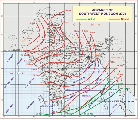
Meanwhile, the IMD said in view of likely formation of a Low Pressure Area over south-east & adjoining east-central Arabian Sea around May 31, conditions were likely to become favourable for onset of south-west monsoon over Kerala around June 1, this year.
Detailed forecast & warnings for next 5 days are as follow:

[the_ad_placement id=”sidebar-feed”]


