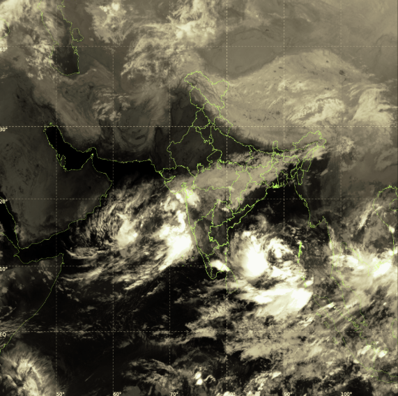
Satellite image of the depression over southeast Bay of Bengal: Pre-Cyclone watch for Andhra Pradesh. Source: IMD
Centre Reviews Preparedness as Cyclone Montha Brews
Andhra, Tamil Nadu Brace for Montha’s Impact
New Delhi: A low-pressure system over the southeast Bay of Bengal is gradually strengthening and is expected to develop into a cyclonic storm within the next 48 hours, according to the India Meteorological Department (IMD). The system, which formed earlier this week, is projected to intensify into a depression by late tonight, a deep depression by tomorrow, and subsequently evolve into a named cyclone — Cyclone Montha — by tomorrow. The name has been contributed by Thailand as part of the regional naming convention for tropical storms in the northern Indian Ocean.
In view of the impending weather system, Cabinet Secretary Dr T. V. Somanathan chaired a meeting of the National Crisis Management Committee (NCMC) on Saturday evening to review the country’s preparedness. The IMD briefed the Committee on the depression’s current status, noting that it had moved nearly westwards at a speed of seven kilometres per hour during the previous six hours and, as of 11:30 a.m. on October 25, lay centred about 950 km east-southeast of Chennai, 960 km southeast of Visakhapatnam, 970 km southeast of Kakinada, and 1,030 km south-southeast of Gopalpur. The IMD informed the NCMC that the system is expected to move west-northwestwards, intensify into a deep depression by October 26, and into a cyclonic storm by the morning of October 27 over the southwest and adjoining west-central Bay of Bengal. Thereafter, it is likely to strengthen into a severe cyclonic storm by October 28 and cross the Andhra Pradesh coast between Machilipatnam and Kalingapatnam, around Kakinada, on the evening or night of October 28, with maximum sustained wind speeds of 90–100 km/h gusting up to 110 km/h.
The Chief Secretaries of Tamil Nadu, Andhra Pradesh, and Puducherry, along with the Additional Chief Secretary of Odisha, briefed the Committee on the precautionary and relief measures being implemented. They reported that evacuation plans had been drawn up for vulnerable coastal belts, with adequate shelters identified and local administrations instructed to ensure readiness. The National Disaster Response Force (NDRF) and State Disaster Response Force (SDRF) have kept teams on standby, while District Control Rooms in all potentially affected areas have been activated.
Fishermen have been advised not to venture into the southwest and adjoining central Bay of Bengal or along and off the coasts of Tamil Nadu, Andhra Pradesh, Yanam (Puducherry), and Odisha from October 26 to 29. Those already at sea have been instructed to return to shore immediately. The Coast Guard reported that more than 900 vessels had already been shepherded back to jetties, and alerts had been issued to remaining crews.
Senior officials from the Ministries of Petroleum and Natural Gas, Fisheries, Power, Telecommunications, Ports, Shipping and Waterways informed the NCMC that all standard operating procedures had been activated and necessary preventive actions taken. The Army, Navy, Air Force, and Indian Coast Guard have placed rescue and relief teams, ships, and aircraft on high alert. The NDRF has pre-positioned teams in vulnerable districts and kept additional contingents ready for immediate deployment. The Union Home Secretary assured that the Ministry of Home Affairs, the National Disaster Management Authority (NDMA), and the IMD are continuously monitoring the system and coordinating with all agencies and State Governments.
Reviewing the preparedness measures, Dr Somanathan stressed the need to ensure zero loss of life and minimal damage to property and infrastructure, and directed that essential services be restored swiftly in the event of any disruption. The meeting was attended by senior officials from the Cabinet Secretariat, the Ministry of Home Affairs, IMD, NDMA, Armed Forces, Coast Guard, and key infrastructure departments.
Meteorologists noted that satellite imagery on Saturday showed an expanding cloud mass and organised convection over the southeast Bay of Bengal. Sea surface temperatures exceeding 29°C and favourable upper-air wind patterns are expected to aid intensification. The IMD’s latest guidance indicates that the storm will move northwestwards over the next 24 hours and gradually curve towards the north-northwest before landfall.
Heavy to very heavy rainfall is forecast over coastal Andhra Pradesh and Rayalaseema from October 27 onwards. Tamil Nadu’s coastal districts, including Chennai, are likely to experience spells of heavy rain from Monday as outer bands of the system influence the region. Southern Odisha and coastal West Bengal may also receive rain and strong winds between October 28 and 29 as the storm tracks inland.
State authorities in Andhra Pradesh have begun pre-emptive measures, including checking drainage systems, identifying vulnerable settlements, and keeping relief centres ready. Tamil Nadu’s Disaster Management Department has activated coastal watch posts, while Odisha has stepped up surveillance along its southern coastline. Puducherry’s administration has issued an advisory suspending all fishing operations until further notice.
IMD officials cautioned that while the forecast track currently points towards the Andhra coast, the final trajectory may still shift depending on upper-tropospheric wind patterns and mid-level humidity. The department will issue updated bulletins every three hours as the system evolves.
As of Saturday evening, the system remained classified as a depression, but meteorologists said conditions are “highly conducive” for further intensification. Coastal residents and maritime operators have been urged to stay informed through official advisories and to follow evacuation instructions where applicable. The situation, officials said, remains under continuous review.
– global bihari bureau