No New Mining Leases till Sustainable Plan Covers Aravallis
Officials Stress that Entire Hill Systems, Slopes, and Ranges are Protected
New Delhi: The Union Government today asserted that “contrary to alarmist claims”, there is “no imminent threat” to the Aravallis’ ecology.
“The Aravalli Hills remain under robust protection through the Ministry of Environment, Forest and Climate Change (MoEF&CC) and coordinated efforts with state governments. The Government reiterates its commitment to ecological preservation, sustainable development, and transparency,” the Centre stated in response to mounting public concerns over a Supreme Court ruling that formally defines these landforms as rising 100 metres or more above local relief.
The Government referred to the Court-approved framework, which, it pointed out, establishes a uniform, operational definition of Aravalli Hills and Ranges alongside binding regulatory measures for mining and related activities. Officials stressed that the 100-metre criterion is not a permissive threshold for extraction but a scientific marker to identify entire hill systems, including slopes, foothills, and connected landforms, all of which remain protected from mining.
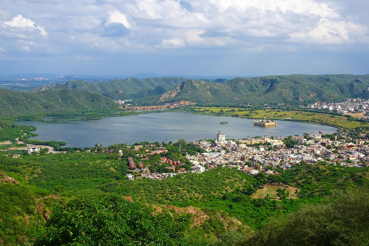
There has been a heightened public attention to the ecological fragility of the Aravallis, which stretch from Delhi through Haryana, Rajasthan, and into Gujarat, and have been recognised in 37 districts for their historical, cultural, and ecological importance. These ancient geological formations act as a natural barrier against northern desertification, serve as groundwater recharge zones, and provide habitats for diverse flora and fauna. Unregulated mining in these areas has long been identified as a serious ecological risk.
In the face of such concerns, the government emphasised that the current operational definitions were developed following extensive consultations by a committee led by the MoEF&CC, pursuant to Supreme Court orders of May 9, 2024, and August 12, 2025. The committee included forest secretaries from Delhi, Haryana, Rajasthan, and Gujarat, as well as representatives from the Forest Survey of India, the Geological Survey of India, and the Central Empowered Committee. Its mandate was to establish a uniform, scientifically robust, and legally enforceable framework for identifying Aravalli Hills and Ranges, particularly in the context of regulating mining activity while ensuring conservation of the landscape.
The committee noted that Rajasthan had already implemented a 100-metre threshold based on a 2002 state report using Richard Murphy’s landform classification, which prohibited mining on hills and their supporting slopes. During deliberations, all concerned states agreed to adopt the same standard while further strengthening the methodology and transparency. Under the framework, any landform rising 100 metres or more above the local relief, as determined with reference to the lowest contour line encircling the landform, is designated as an Aravalli Hill. The protection extends to the entire landform within the contour, including slopes and associated landforms, regardless of gradient. Officials clarified that it is therefore incorrect to conclude that mining is automatically permissible on landforms below 100 metres.
The Aravalli Ranges are defined as clusters of two or more Aravalli Hills within 500 metres of each other, measured from the outermost points of their lowest contour lines. Intervening land between such hills, determined through a buffer-and-intersection mapping procedure, is also protected. This cluster-based approach ensures continuity of ecological corridors, safeguards wildlife habitats, and maintains the integrity of the ridge system. The government highlighted that this definition addresses prior gaps in range protection absent in earlier state-level frameworks.
The committee further recommended mandatory marking of all Aravalli Hills and Ranges on Survey of India maps before any mining activity, explicit identification of core and inviolate areas where mining is strictly prohibited, and detailed guidance for sustainable mining and prevention of illegal operations. Core areas include protected regions such as tiger reserves, eco-sensitive zones, wetlands, Compensatory Afforestation Fund Management and Planning Authority (CAMPA) plantations, and other conservation investment areas. Narrow exceptions are allowed only for atomic, critical, and strategic minerals under the Mines and Minerals (Regulation and Development) Act of 1957 (MMDR Act), subject to rigorous safeguards.
To prevent a regulatory vacuum, the Supreme Court, the government noted, has imposed a freeze on new mining leases until the MoEF&CC, in consultation with the Indian Council of Forestry Research and Education (ICFRE), prepares a Management Plan for Sustainable Mining (MPSM) for the Aravallis. The MPSM will consider the Aravallis as a continuous ridge from Gujarat to Delhi, identify areas where mining may be permissible under strict ecological criteria, assess cumulative environmental impacts, and mandate detailed post-mining restoration and rehabilitation measures. Existing operations must comply with environmental and forest clearances, including six-monthly joint inspections and groundwater safeguards, and may be suspended for non-compliance.
The government also highlighted enforcement against illegal mining as a core component of the framework. Measures include drone and night-vision Close Circuit Television (CCTV) surveillance, high-tech weighbridges, e-challan systems for mineral dispatch tracking, trenches on access routes, district-level task forces combining forest, mining, revenue, and police authorities, toll-free control room lines for complaints, and immediate closure of unauthorized operations. Repeat violations can trigger revocation of environmental clearances or consent to operate, alongside penalties.
Officials stressed that these measures collectively protect the ecological functions of the Aravallis: maintaining their role as a barrier against desertification, safeguarding groundwater recharge zones, preserving biodiversity habitats and corridors, and supporting the environmental health of the Delhi-NCR region. The government rejected claims of imminent ecological threat as alarmist, noting that ongoing afforestation, eco-sensitive zone notifications, strict mining regulations, and landscape-level planning collectively secure the Aravalli ecosystem for present and future generations.
In conclusion, the government stressed that the Aravalli Hills and Ranges are under a comprehensive, Court-approved legal framework that clarifies landform definitions, mandates landscape-level protection, regulates mining, and strengthens enforcement mechanisms. Officials maintain that the 100-metre criterion, central to the framework, functions as a scientific tool to preserve the integrity of the hills, their slopes, and associated landforms, while enabling informed and sustainable governance of one of India’s most ecologically significant and historically important landscapes.
– global bihari bureau


🌳🏞️ Good to know the Aravallis are under strong protection! With the Court-approved framework, slopes, foothills, and ranges are safe, illegal mining is being monitored, and a sustainable plan is in place. Nature and future generations matter! 💧🦌💚