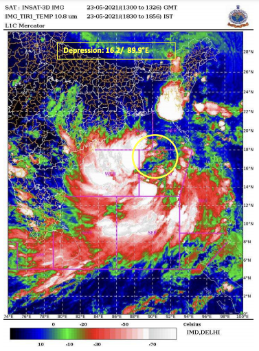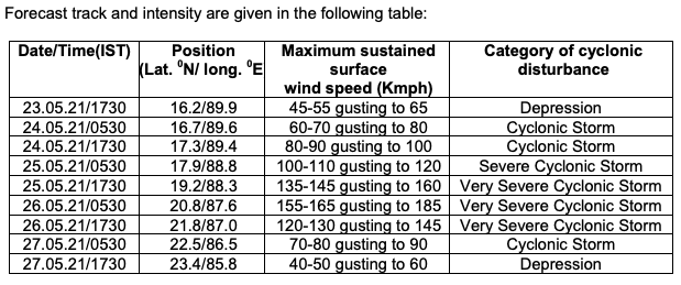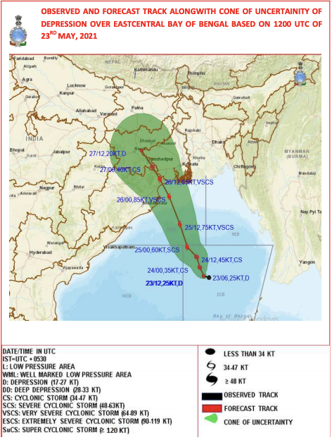
New Delhi: The Depression over east-central Bay of Bengal is very likely to move slowly north-north-westwards and intensify into a Cyclonic Storm by May 24 morning and further into a ‘Very Severe Cyclonic Storm’ during the subsequent 24 hours. It would continue to move north-north-westwards, intensify further and reach Northwest Bay of Bengal near north Odisha and West Bengal coasts by May 26 morning. It is very likely to cross north Odisha – West Bengal coasts between Paradip and Sagar islands by evening of May 26 as a ‘Very Severe Cyclonic Storm’.

The National Weather Forecasting Centre of the India Meteorological Department (IMD) today forecasted heavy to very heavy rains at a few places with extremely heavy falls in Balasore, Bhadrak, Kendrapara, Mayurbhanj and heavy to very heavy falls at a few places in Jagatsinghpur, Cuttack, Jajpur, Keonjhar on May 26 and heavy to very heavy rainfall at isolated places in north interior Odisha on May 27, 2021. In its forecast for West Bengal, it warned of extremely heavy rainfall at isolated places over Jhargram, Medinipur, North & south 24 Parganas, Howrah, Hooghly, Kolkata and heavy to very heavy rainfall at a few places over Nadia, Bardhaman, Bankura, Purulia, Birbhum and heavy falls at isolated places over Murshidabad, Malda and Dakshin Dinajpur Districts on May 26. There will be further heavy to very heavy rain at isolated places in Malda and Darjeeling, Dinajpur, Kalimpong, Jalpaiguri, Sikkim and heavy rain at a few places over Bankura, Purulia, Bardhaman, Bhirbhum and Murshidabad on May 27.

IMD also warned of extremely heavy rainfall over southeast Jharkhand and heavy to very heavy rainfall at isolated places over Assam and Meghalaya on May 26 and 27. Bihar too will experience very heavy rainfall on May 27.

Squally wind speed reaching 40-50 kmph gusting 60 kmph is very likely to prevail over North Bay of Bengal and along and off Odisha – West Bengal – Bangladesh coasts from the evening of May 24. It would increase gradually becoming 50-60 kmph gusting to 70 kmph from May 25 evening. It would further increase becoming gale wind speed 60-70 kmph gusting to 80 kmph from mY 26 early hours over northwest Bay of Bengal and along and off West Bengal AND north Odisha and Bangladesh coasts. It would gradually increase further becoming 90-100 gusting to 110 kmph from May 26 morning and increase thereafter becoming 155-165 kmph gusting to 185 kmph at the time of landfall till May 26 afternoon.
Sea conditions will be rough to very rough over Andaman Sea and adjoining eastcentral Bay of Bengal on May 24, high to very high / phenomenal over major parts of central Bay of Bengal, north Bay of Bengal and along and off Odisha – West Bengal – Bangladesh coasts during May 24– 26.
The Met Office has advised those who are out in the Deep Sea of north and adjoining central Bay of Bengal to return to the coast.
– global bihari bureau


