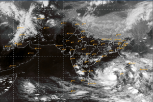
New Delhi: A well-marked low-pressure area over southeast Bay Of Bengal and the adjoining Andaman Sea is very likely to move northwestwards and intensify into a Cyclonic Storm over the east-central Bay Of Bengal tomorrow, May 8, 2022, the India Meteorological Department warned today. The sea condition is rough to very rough over the southeast Bay of Bengal and adjoining Andaman Sea.
It is very likely to continue to move northwestwards till 1200 Utc [Coordinated Universal Time] of May 10 and reach west-central and adjoining northwest Bay Of Bengal Off north Andhra Pradesh and Odisha coasts. Thereafter, it is very likely to recurve north-northeastwards and move towards the northwest Bay Of Bengal off the Odisha coast.
The intensity of the system is T1.5, associated with scattered to broken low and medium clouds with embedded intense to very intense convection layover area between latitude 7.0 north and 15.0 north and longitude 86.0 East and 93.0 east and Andaman & Nicobar Islands. The minimum cloud top temperature is minus 93 degrees Celcius. Convection has further organised during the past 3 hours over South Andaman Sea and adjoining southeast Bay of Bengal.
According to the IMD, the well-marked low-pressure area over southeast Bay Of Bengal and adjoining the Andaman Sea moved northwestwards, concentrated into a depression and lay centred at 0600 Utc of today, over the same region near latitude 9.4°N and longitude 91.3°E, about 170 km west of Car Nicobar, 300 km south-southwest of Port Blair, 1270 km southeast of Visakhapatnam (43149) and 1300 km south-southeast Of Puri.
– global bihari bureau


